 |
| Ed covers safety and back country ethics principles at the TH. |
A brief pit stop at the Conoco Plaza on I-70, prepared everyone for a day on the slopes of the Arapaho National Forest, and Vasquez Peak Wilderness. We arrive at the TH (10,434'), and cinch into our day packs. Ed provided instructions on the importance of remaining within a reasonable distance to the hiker in front. Hikers were also reminded to be sure to inform Ed when taking 'separation' time.
 |
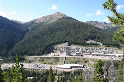
| Henderson Mine, North Americas largest producer: 40 mm lbs./year and value of $1.1 billion.. |
We were on trail before 9:30 as the sun was beginning to make it's presence known. A few long and lazy switchbacks on the Henderson Spur Trail, took us 1.5 mi. from the TH. Clear views of the huge mine complex continued for the early part of the morning.
Areas of thick sub-alpine vegetation kicked at our legs as we crossed a number of drainages. A few springs provided comforting sounds of falling water from time to time as we climbed.
The spur trail would end at a junction with the Continental Divide Trail (CDT), around 11,250'el. Now above treeline, Red Mountain (12,315'), plus a series of 11 and 12,000' peaks came into full view. The CDT continues parallel with the Mt. Nystrom Trail, along Vasquez Ridge before splitting farther up slope.
 |
| Cow Parsnips and Western Aster cover the slope along Vasquez Ridge. |
At 2.6 mi., trail curves sharply and crosses another stream. Trees are sparse here, as is any low growth willow. Our approach to the Pass took us along the slope and into a gulch loaded with alpine grasses and other vegetation.
 |
| Above 11,100' el., trees thin out and alpine tundra takes over. |
 |
| Ed stands on a saddle before the Pass, as members of the group approach. |
The pass was a great spot for the group photo. Unfortunately, the sun decided to remain behind dense clouds while we captured the moment. No wind, no wildlife and no other hikers until later in our descent from the pass. A couple and their dog came from behind us. First the woman, who seemed in great shape told us she and her husband began this morning at 9:30 and hiked some 12 miles today. She did it all in sandals.
 |
| A Rosy Indian Paintbrush stands among a pile of weathered trees. |
The group split, some walking to the Hard Rock Cafe, others crossed the street...the only one in town...for ice cream.
One thing occurred with this group today, and this is a first, of sorts. For the first time since this hiker has been hiking with the group (7 years), the group was evenly split, 6 men and 6 women.
Total miles = 6.2
Total elevation gain = 1,216'


After years of battling COPD with little to no lasting relief, I turned to the herbal treatment from NaturePath Herbal Clinic—and it’s one of the best decisions I’ve made.
ReplyDeleteWithin just four months, I experienced noticeable improvements: easier breathing, reduced coughing, and a significant decrease in chest tightness. I'm now able to walk longer distances, sleep more soundly, and enjoy daily activities without constant fatigue or shortness of breath.
This treatment has genuinely transformed my quality of life. If you're seeking a natural and effective solution for COPD, I wholeheartedly recommend NaturePath Herbal Clinic.
Learn more: www.naturepathherbalclinic.com