I was invited to do this hike as a member of Outdoor Mindset (OM). Last year, I was referred to the Boulder based organization by the Parkinson's Association of the Rockies.
OM exists to unite and inspire people affected by neurological challenges through a common passion for the outdoors. Focus is on building lasting relationships and the outdoors. Staff members at OM encourage people to change their perceptions of diagnosis from limitation to opportunity.
That is exactly what I have found with OM members. Regardless of ones individual issues, we all have one thing in common...we love the outdoors.
I arrived at the TH before the established meeting time of 7 a.m. If you don't know how passionate people in Boulder are about outdoor activities, go to any street corner, back lot, college (CU) campus, highway, country road, footpath, or stream, leading into town, and you will find a steady stream of ultra-fit men and women working...playing...at their passion.
OM Director of Programs & Membership, Patti Abendroth, organized the day hike. While lacing my boots, Patti drove into the parking lot. Minutes later find Linda and Dan Reynolds arrived. My wife and me had met the couple weeks earlier at a picnic sponsored by OM. We hit it off immediately and spent a few hours talking about anything and everything.
Unlike facebook, where a person gets pumped up with the number of "Virtual friends" he/she has, these friendships are real. In the end, it's not the number of friends, rather it is the solid friendships one has that defines a person.
Friday, August 31, 2012
Niwot Ridge Trail - IPW
It was one of the smallest HCH (High Country Hiker) groups of the year, for a hike that in terms of scenery was better than some this year. In terms of difficulty, it was not. For the nine who did make it, including two first-timers, it was a wonderful day.
So really, what part of Indian Peaks Wilderness (IPW) is nothing short of just plain incredible back country. Every time I go thru the mountain town of Nederland, It feels like the pace of life drops a few notches. Again, when Ed turns on to Brainard Lake Road, we are in the Brainard Lake Recreation Area. From here virtually all signs of civilization are behind us.
The Niwot Cutoff Trail heads west from the TH for .6 mi. to Long Lake. A section of wood plank walkways leads to the Jean Lunning Trail for a short distance to the junction with Niwot Ridge Trail.
Elevation gain begins immediately to Niwot Ridge at 11,000'el. Sections of loose rock force hikers to pay attention to placement of every footstep. As we approach the rifge, views of Long Lake are exceptional.
The peaks that make the area on of the premier hiking venues close to Denver, are in clear sight to the west including: South and North Arapaho (13,xxx'), with the Arapaho Glacier tucked between them;Arikaree (13,150'); Navajo (13,499'); Apache (13,41'); and Shoshoni (12,967'). Iabelle Glacier is the prominent feature between Apache and Shoshoni peaks.
Pawnee Pass and peak (12,943'), by the same name plus Little Pawnee Peak (12,466') stand tall in a line - all of them can be crossed via the Continental Divide Trail. Continuing around the eastern edge of NIwot Ridge, Left Hand Park cannot be missed. To the right is Niwot Mountain (11,471').
At the junction with NIwot Ridge Trail, we continue past an environmental observation station and on to an obercation building at approx. 11,600'.
Note: Niwot Ridge has been designated by the United Nations as an International Biosphere Reserve for artic and alpine research. Wlinds of up to 160 mph - strongest recorded in North America.
The biosphere reserve is administered cooperatively by the U. S. Forest Service and the University of Colorado for experimental and long-term studies of alpine tundra.
It is one of the National Science Foundations long-term ecological research sites, and has been used by the National Oceanic and Atmospheric Administration (NOAA) for atmospheric trace gas sampling since 1968.
In winter, snow shoers and Xcountry skiers can be found enjoying the Niwot Ridge Trail.
Trail physically ends at approximately 12,150' el. The top of Niwot is just over 12,280' el. We stopped for lunch at approx. 11,250' el.
Areas of dense Krumholtz dot the landscape up here and not much else. A few small rock outcroppings were all the protection we had for lunch.
Total miles = 5.7
Total elevation gain = 1,000'
Trailhead elevation = 10,500'
Ridge top elevation = 11,557'
 |
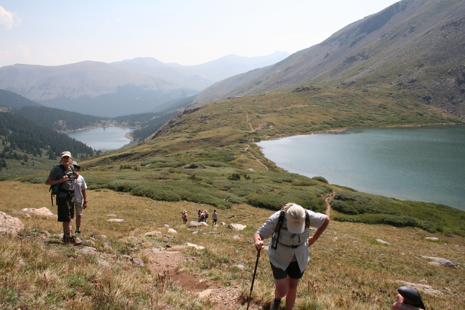
| Mid-morning, hikers are steppin' out and up. |
So really, what part of Indian Peaks Wilderness (IPW) is nothing short of just plain incredible back country. Every time I go thru the mountain town of Nederland, It feels like the pace of life drops a few notches. Again, when Ed turns on to Brainard Lake Road, we are in the Brainard Lake Recreation Area. From here virtually all signs of civilization are behind us.
The Niwot Cutoff Trail heads west from the TH for .6 mi. to Long Lake. A section of wood plank walkways leads to the Jean Lunning Trail for a short distance to the junction with Niwot Ridge Trail.
 |
| First time hiker, Marian, is followed by Al and Nancy. |
Elevation gain begins immediately to Niwot Ridge at 11,000'el. Sections of loose rock force hikers to pay attention to placement of every footstep. As we approach the rifge, views of Long Lake are exceptional.
 | |
| All Nancy can say is WOW!...WOW!...WOW! |
The peaks that make the area on of the premier hiking venues close to Denver, are in clear sight to the west including: South and North Arapaho (13,xxx'), with the Arapaho Glacier tucked between them;Arikaree (13,150'); Navajo (13,499'); Apache (13,41'); and Shoshoni (12,967'). Iabelle Glacier is the prominent feature between Apache and Shoshoni peaks.
 |
| A quick break close to the top. |
Pawnee Pass and peak (12,943'), by the same name plus Little Pawnee Peak (12,466') stand tall in a line - all of them can be crossed via the Continental Divide Trail. Continuing around the eastern edge of NIwot Ridge, Left Hand Park cannot be missed. To the right is Niwot Mountain (11,471').
 |
| Trail passes a structure used by personnel |
At the junction with NIwot Ridge Trail, we continue past an environmental observation station and on to an obercation building at approx. 11,600'.
Note: Niwot Ridge has been designated by the United Nations as an International Biosphere Reserve for artic and alpine research. Wlinds of up to 160 mph - strongest recorded in North America.
The biosphere reserve is administered cooperatively by the U. S. Forest Service and the University of Colorado for experimental and long-term studies of alpine tundra.
It is one of the National Science Foundations long-term ecological research sites, and has been used by the National Oceanic and Atmospheric Administration (NOAA) for atmospheric trace gas sampling since 1968.
In winter, snow shoers and Xcountry skiers can be found enjoying the Niwot Ridge Trail.
 |
| Al tries to get comfy among the many partially exposed rocks. |
Trail physically ends at approximately 12,150' el. The top of Niwot is just over 12,280' el. We stopped for lunch at approx. 11,250' el.
 |
| Red Dahlia, |
 |
| White Dahlia. |
Total miles = 5.7
Total elevation gain = 1,000'
Trailhead elevation = 10,500'
Ridge top elevation = 11,557'
Monday, August 27, 2012
Never Summer Wilderness - A Place of Bewildering Vastness
The views, unexpected wildlife sightings, and unending solitude make every backpack trip worthwhile. But now, new research shows, staying home is just plain dumb..." So begins an exclusive report in the May issue of Backpacker the outdoors at your doorstep magazine.
The day it's front cover peeks out of the pile of political trash, promotional ads, and the menu of the latest take-out restaurant to open in town, I have some serious reading to do. More on this later.
Since developing a "Life List" a few years ago, at least one multi-day back country trip has been on it. Years of East Coast treks across trail systems in Pennsylvania, i.e. Tuscarora, Susquehannock, Mid-State, Horse Shoe, Old Loggers Path, Black Forest, and the granddaddy of them all, The Appalachian Trail, taught me many lessons.
Always looking for that next adventure, four multi-day trips, were developed on paper. The one I could not stop researching had to do with the name, Never Summer Wilderness. Every time I saw those words, I found myself looking it up on the web, or paging thru old Backpacker magazines for features on the area.
January, my birthday month, is normally when I begin thinking seriously about refining "The List" and refine plans for the #1item on the list.
The header on this itinerary read:
This would not be a solo endeavor. The criteria for anybody to sign on included some backpacking experience, back country survival skills, plus they had to be mentally and physically fit.
As a member of the High Country Hiker (HCH) group, based at the Aurora Center for Active Adults (ACAA). I was hiking every week with men and women who met the criteria. No need for a bunch of phone calls, or emails.
A conversation with ACAA van driver and hike leader, Ed Blum provided an opportunity to explain my plan. Ed seemed interested, but he did not have all the necessary gear, plus he had not been on a multi-day trip for some time.
A few weeks later, Ed asked me to go shopping...for a new pack. We talked more and more during day hikes with the HCH group about the trip. Well into summer now, I was unsure who the third member of the party would be.
That question was answered when John and Kathy Tedrick joined the HCH group. It was obvious John had the experience, skills and knowledge needed to survive in the back country. John had been on many multi-day trips and had one planned just prior to this one. When asked if he would join us, he gladly accepted.
In the weeks leading up to day one, the three of us met for breakfast a few times, traded email, and a number of phone calls before the itinerary was considered a lock. A few visits to REI for essentials, and we were set.
The day it's front cover peeks out of the pile of political trash, promotional ads, and the menu of the latest take-out restaurant to open in town, I have some serious reading to do. More on this later.
Since developing a "Life List" a few years ago, at least one multi-day back country trip has been on it. Years of East Coast treks across trail systems in Pennsylvania, i.e. Tuscarora, Susquehannock, Mid-State, Horse Shoe, Old Loggers Path, Black Forest, and the granddaddy of them all, The Appalachian Trail, taught me many lessons.
Always looking for that next adventure, four multi-day trips, were developed on paper. The one I could not stop researching had to do with the name, Never Summer Wilderness. Every time I saw those words, I found myself looking it up on the web, or paging thru old Backpacker magazines for features on the area.
January, my birthday month, is normally when I begin thinking seriously about refining "The List" and refine plans for the #1item on the list.
The header on this itinerary read:
Baker/Bowen Gulch Loop
Never Summer Wilderness (NSW)
Arapaho/Routt National Forest and RMNP
August, 15 to 19, 2012.
This would not be a solo endeavor. The criteria for anybody to sign on included some backpacking experience, back country survival skills, plus they had to be mentally and physically fit.
As a member of the High Country Hiker (HCH) group, based at the Aurora Center for Active Adults (ACAA). I was hiking every week with men and women who met the criteria. No need for a bunch of phone calls, or emails.
A conversation with ACAA van driver and hike leader, Ed Blum provided an opportunity to explain my plan. Ed seemed interested, but he did not have all the necessary gear, plus he had not been on a multi-day trip for some time.
A few weeks later, Ed asked me to go shopping...for a new pack. We talked more and more during day hikes with the HCH group about the trip. Well into summer now, I was unsure who the third member of the party would be.
That question was answered when John and Kathy Tedrick joined the HCH group. It was obvious John had the experience, skills and knowledge needed to survive in the back country. John had been on many multi-day trips and had one planned just prior to this one. When asked if he would join us, he gladly accepted.
In the weeks leading up to day one, the three of us met for breakfast a few times, traded email, and a number of phone calls before the itinerary was considered a lock. A few visits to REI for essentials, and we were set.
Friday, August 24, 2012
Herman Gulch Trail - CDT
Thirteen members of the Aurora High Country Hiker (HCH) group based at the Aurora Center for Active Adults were as enthusiastic as a bus load of school kids. No, they were not going to the zoo or the water park. They were headed for exit # 218 on I70, and the Herman Gulch trail head.
The morning air was still cool when the van pulled into the parking lot minutes before 9:00 a.m. Everybody was familiar with the routine before a hike, i.e. make your pit stop, cinch into your day pack, adjust your poles, and move to the trail head marker for instructions from Ed.
This is a popular hike in Summer because the trail head is literally a few yards from I70. Trail begins on an old sawmill road, and immediately starts climbing from 10,400,' through thick stands of fir and aspen.
The obnoxious sounds of belching 18-wheelers, diesel pickups spewing hideous fumes, and family campers blowing choking black smoke out their tail pipes - all of it replaced with the sound of water tumbling over rocks a few yards below trail. I inhale deeper as I get farther from the trail head...a comforting thought.
What if every body had to walk everywhere they wanted to go? The words of John Lennon seem appropriate here. "...Imagine no possessions, I wonder if you can, no need for greed or hunger, a brotherhood of man, imagine all the people sharing all the world. You, may say I'm a dreamer, but I'm not the only one, I hope some day you'll join us, And the world will live as one"
Every trail has an unforgettable feature, odd shaped tree, or unique looking rock. This time, it was a web of tree roots that seemed to jump out. A network of intertwined growth that is bound to slow a hikers pace.
The forest is soon replaced with treeless landscapes and views of the Continental Divide ahead. As we climb, Mount Bethel (12,705') is in plain view to our left, followed by two more mountains each topping over 12,000'.
On our right, three more monster mountains including one named Woods (12,940'), with it's steep slopes and huge rock slides are intimidating as well.
Trail here continues parallel with runoff waters from the tarn high above. Like many trails in Colorado, this one is for those who are deemed fit of body, mind and spirit.
Trail makes a loop right to a junction. Here, the CDT (Continental Divide Trail) goes off to the right while we continue our climb of the last 150+' to Herman Lake.
The lake, named after timber operator Herman Hassell, is seated in a bowl at 12,000' below Pettingell Peak (13,553'). As mentioned, this is a popular hike. One author calls it a "100 wildflower" trail because it is possible to see that many different flower species during peak bloom in late July. We missed the color fest this time.
If you are considering this hike, know that it is "Moderate to Difficult," depending on the source. Although most members of HCH are experienced trekkers, for some this hike was a challenge. Note: We bid farewell to one of our members who will be relocating out of Colorado. We wish her safe travel.
Total Miles: 6.7
Total Elevation Gain: 1,700'
The morning air was still cool when the van pulled into the parking lot minutes before 9:00 a.m. Everybody was familiar with the routine before a hike, i.e. make your pit stop, cinch into your day pack, adjust your poles, and move to the trail head marker for instructions from Ed.
 |
| In the open, views like this one are around every turn. |
This is a popular hike in Summer because the trail head is literally a few yards from I70. Trail begins on an old sawmill road, and immediately starts climbing from 10,400,' through thick stands of fir and aspen.
 |
| A steep up is behind us...many more ups are ahead. |
The obnoxious sounds of belching 18-wheelers, diesel pickups spewing hideous fumes, and family campers blowing choking black smoke out their tail pipes - all of it replaced with the sound of water tumbling over rocks a few yards below trail. I inhale deeper as I get farther from the trail head...a comforting thought.
What if every body had to walk everywhere they wanted to go? The words of John Lennon seem appropriate here. "...Imagine no possessions, I wonder if you can, no need for greed or hunger, a brotherhood of man, imagine all the people sharing all the world. You, may say I'm a dreamer, but I'm not the only one, I hope some day you'll join us, And the world will live as one"
Every trail has an unforgettable feature, odd shaped tree, or unique looking rock. This time, it was a web of tree roots that seemed to jump out. A network of intertwined growth that is bound to slow a hikers pace.
 |
| Roots or a scene from The Hobbit. |
The forest is soon replaced with treeless landscapes and views of the Continental Divide ahead. As we climb, Mount Bethel (12,705') is in plain view to our left, followed by two more mountains each topping over 12,000'.
 |
| Looking at 13,195' Pettingell Peak. |
On our right, three more monster mountains including one named Woods (12,940'), with it's steep slopes and huge rock slides are intimidating as well.
Trail here continues parallel with runoff waters from the tarn high above. Like many trails in Colorado, this one is for those who are deemed fit of body, mind and spirit.
Trail makes a loop right to a junction. Here, the CDT (Continental Divide Trail) goes off to the right while we continue our climb of the last 150+' to Herman Lake.
 |
| Junction of CDT (R) and Herman Gulch Trail. |
The lake, named after timber operator Herman Hassell, is seated in a bowl at 12,000' below Pettingell Peak (13,553'). As mentioned, this is a popular hike. One author calls it a "100 wildflower" trail because it is possible to see that many different flower species during peak bloom in late July. We missed the color fest this time.
 |
| Herman Lake |
If you are considering this hike, know that it is "Moderate to Difficult," depending on the source. Although most members of HCH are experienced trekkers, for some this hike was a challenge. Note: We bid farewell to one of our members who will be relocating out of Colorado. We wish her safe travel.
 |
| Front seated (L - R) Dorothy Stromberg, Dorothy (last hike) Slater, and Kathy Tedrick; Standing (L to R) Nancy, Mary K., Lisse, and John; Back (L to R) Judy, Raheal (1st timer), Ed, Penny, and Gary1 |
Total Miles: 6.7
Total Elevation Gain: 1,700'
Wednesday, August 22, 2012
Coming Soon...A Wilderness Odessy!
The hiker is writing his journal entry describing the latest and most challenging backpack trip of his life. Be watching for his post here on this blog.
Silver Dollar Lake
A number of cancellations resulted in a hiking season low of nine High Country Hikers who boarded the van headed for Georgetown. The newly resurfaced Guanella Pass Road-less the curves-seemed like I-25 compared to the service road leading to our destination.
The trail head had no facilities, forcing hikers to decide if and when they would call for separation from the group. Trail began with a number of turns through spruce and pine forest before it makes a steady climb along the south side of a narrow valley. The thick forest soon thins as we cross a small creek and gain altitude.
Stands of alpine willow line both sides of trail. Exposed legs take a beating from their branches. Talk about rocks...even the nimble footed among us are slowed by jagged, then smooth, then loose rock, both on the ascent and again when we return.
Soon, the first of three lakes appears. The privately owned Naylor Lake, from a distance, seems to be a secluded paradise. One small fishing boat can be seen gliding across the mirrow-still lake without making a wave. As great as it must be to live or be a guest there, one question comes to mind. Is the place worth the effort needed to bring everything required to sustain it.
Trail soon reaches timberline as it continues along Square Top Mountain (13,794'), to our left. We make steady progress and as we approach Silver Dollar Lake (11,950'), the massive landscape gives one the feeling of being in a special place.
But wait, trail continues, and it continues to go UP. Could there be another lake to explore?
Without question, the climb of 280' more, is well worth the effort. We are treated to the scenic Murray Lake (12,228') and a landscape not often seen in Colorado. From any spot on the ridge, one can see three alpine lakes, in a row.
Above tree line, there is not much cover from the sun, or steady wind. Hikers are forced to pick a rock, a clump of alpine grass, or log to sit on for lunch. A fleece or wind shell helps retain body heat for some. A few lucky souls sequester themselves by small rock outcroppings for protection.
The eye can't miss Argentine Peak (13,738') from most any spot around the lake. Not far to the North, the Continental Divide Trail hugs the ridge line.
Across the tundra to our right is the imposing Mount Wilcox (13,408'). Although these mountains are treeless, they somehow provide a sense of beauty and stability. Without question, this hiker stopped on trail numerous times today to simply "Enjoy the Journey."
Wildflowers normally capture hikers attention on this trek. This late in the summer, we only found a few pockets of Mountain Gentian. Bright yellow Snow Buttercups and red Indian Paint Brush captured the attention of the camera.
While going across a boulder field, the high pitched squeek of a Pika was heard. Seconds later it scampered among the massive rocks, stopping long enough to be captured by the lens.
Total Miles: 4.5 RT
Total Elevation Gain: 1,000'
The trail head had no facilities, forcing hikers to decide if and when they would call for separation from the group. Trail began with a number of turns through spruce and pine forest before it makes a steady climb along the south side of a narrow valley. The thick forest soon thins as we cross a small creek and gain altitude.
 |
| After leaving the TH, everybody feels strong |
Stands of alpine willow line both sides of trail. Exposed legs take a beating from their branches. Talk about rocks...even the nimble footed among us are slowed by jagged, then smooth, then loose rock, both on the ascent and again when we return.
 |
| Hikers are challenged by thick willow, rock steps, and runoff. |
Soon, the first of three lakes appears. The privately owned Naylor Lake, from a distance, seems to be a secluded paradise. One small fishing boat can be seen gliding across the mirrow-still lake without making a wave. As great as it must be to live or be a guest there, one question comes to mind. Is the place worth the effort needed to bring everything required to sustain it.
 |
| Lake Naylor is inviting. |
Trail soon reaches timberline as it continues along Square Top Mountain (13,794'), to our left. We make steady progress and as we approach Silver Dollar Lake (11,950'), the massive landscape gives one the feeling of being in a special place.
 |
| Silver Dollar Lake is over the ridge. |
But wait, trail continues, and it continues to go UP. Could there be another lake to explore?
Without question, the climb of 280' more, is well worth the effort. We are treated to the scenic Murray Lake (12,228') and a landscape not often seen in Colorado. From any spot on the ridge, one can see three alpine lakes, in a row.
 |
| Sharon pauses to catch her breath, followed by Ed and Gary1. |
Above tree line, there is not much cover from the sun, or steady wind. Hikers are forced to pick a rock, a clump of alpine grass, or log to sit on for lunch. A fleece or wind shell helps retain body heat for some. A few lucky souls sequester themselves by small rock outcroppings for protection.
 |
| Judy (L) and Ed (Center), have lunch. |
The eye can't miss Argentine Peak (13,738') from most any spot around the lake. Not far to the North, the Continental Divide Trail hugs the ridge line.
 |
| Masha enjoys the view. |
Across the tundra to our right is the imposing Mount Wilcox (13,408'). Although these mountains are treeless, they somehow provide a sense of beauty and stability. Without question, this hiker stopped on trail numerous times today to simply "Enjoy the Journey."
 |
| Mountain Gentian dot the landscape. |
Wildflowers normally capture hikers attention on this trek. This late in the summer, we only found a few pockets of Mountain Gentian. Bright yellow Snow Buttercups and red Indian Paint Brush captured the attention of the camera.
 |
| Snow Buttercup has corrugated petals and grows in a bog |
While going across a boulder field, the high pitched squeek of a Pika was heard. Seconds later it scampered among the massive rocks, stopping long enough to be captured by the lens.
 |
| Pika poses if for only a second. |
Total Miles: 4.5 RT
Total Elevation Gain: 1,000'
 |
| High Country Hikers (Standing L - R) Sharon, Dorothy, Marsha, Judy, and Jonelle. (Seated L - R) Penny, Ed, and Johanna |
Friday, August 10, 2012
10 Ways to Help You Live a Healthy Lifestyle
One of the three elements of this blog from day one has been (see the home page banner) to promote a healthy lifestyle. The first of ten suggestions was posted on August 1, 2011. It was simply to "Stay Active" both physically and mentally. It was not only the first posting of this column, it was (and still is) #1 on my list.
The fight against Parkinson's is constant. Staying active both physically and mentally is at the core of why I have been able to fight off the PD "bug" throughout my body since being diagnosed in 2004.
Since that first post, four more of the ten suggestions for a healthy lifestyle have been made.
So what is the topis this time?
#8: Be Pro-active in managing change. How? These are the things I try to do.
The fight against Parkinson's is constant. Staying active both physically and mentally is at the core of why I have been able to fight off the PD "bug" throughout my body since being diagnosed in 2004.
 | ||||||
| A year after left knee surgery and a self-imposed 100-mile challenge was one way to walk the walk. In my case, that meant hike the hike. This hike in Eldorado Canyon was to celebrate completion of that challenge and do it with fellow hikers and friends from Outdoor Mindset. The organization dedicated to supporting those with neurological disorders. | . | . |
Since that first post, four more of the ten suggestions for a healthy lifestyle have been made.
- Challenge Yourself at #5 - May 4, 2012
- Adopt a healty diet at #9 - August 17, 2011
- Don't let physical limitations isolate you at #2 - August 28, 2011
- Nourish your friendshiips; past and present at #10 - March 16, 2012
So what is the topis this time?
#8: Be Pro-active in managing change. How? These are the things I try to do.
- Research the topic
- Know what to expect
- Understand the up and down side
- Learn to accept the facts
- Network with positive and forward thinking people
- Find those with experience to help you cope
- Start each day with a grateful attitude
- Live each day to the best of your ability
- End each day with no regrets
- Get outside, get happy, spend time in nature
Thursday, August 9, 2012
Dear, Deer Mountain
It was good to see all 14 seats on the van taken this week. For the third consecutive week, our destination was RMNP. After two top shelf hikes in a row to Crater, and Mills Lakes, Deer Mountain might not sound as awe..some. But wait till you hear about it.
It was this hikers fourth trip to the summit, but it was no less challenging or spectacular than the first. More of a physical challenge because of the 39# 7.5 oz. pack I was toting, (more later).
Ed turned off Trail Ridge Road just before 10:00 a.m., then eased the van into the last space big enough for a vehicle of some girth.
Everyone gathered at the trail head (TH) 8,920,' for Ed's WOW (words of wisdom) message, before heading for those long lazy switchbacks. The lower part of this trail provided enough of a challenge to get the adrenalin flowing. If the physical part was no problem the visual grandeur surely became a keeper within 20 minutes on trail. Take the lush green meadow known as Moraine Park. The first benchmark of RMNP when visitors enter the park at Beaver Meadows Station.
Switchback after switchback causes the tiny images we know as people, vehicles, an elk, or a pocket of construction workers in their eye-catching vests become even smaller dots on the landscape, as we gain elevation..
One feature that never gets smaller is Long's Peak with it's distinctive summit. Many on trail today would have a story to tell about Long's from personal experience, if you ask them.
It was this hikers fourth trip to the summit, but it was no less challenging or spectacular than the first. More of a physical challenge because of the 39# 7.5 oz. pack I was toting, (more later).
Ed turned off Trail Ridge Road just before 10:00 a.m., then eased the van into the last space big enough for a vehicle of some girth.
Everyone gathered at the trail head (TH) 8,920,' for Ed's WOW (words of wisdom) message, before heading for those long lazy switchbacks. The lower part of this trail provided enough of a challenge to get the adrenalin flowing. If the physical part was no problem the visual grandeur surely became a keeper within 20 minutes on trail. Take the lush green meadow known as Moraine Park. The first benchmark of RMNP when visitors enter the park at Beaver Meadows Station.
 |
| Why do YOU hike? |
Switchback after switchback causes the tiny images we know as people, vehicles, an elk, or a pocket of construction workers in their eye-catching vests become even smaller dots on the landscape, as we gain elevation..
One feature that never gets smaller is Long's Peak with it's distinctive summit. Many on trail today would have a story to tell about Long's from personal experience, if you ask them.
 |
| Marsha (in white) takes on another switchback, followed by Jonelle, Kathy, Mark K., Nancy and Penny. |
Tuesday, August 7, 2012
Hooked on backpacking
Near the end of a 35-year work career, one conversation with a co-worker changed everything. The line went something like this. One of the machine operators does crazy stuff. He goes out in the mountain for days at a time. He carries a big pack thing on his back.
My interest had been sparked. I had to meet this crazy mountain man.
Turns out I knew the guy. I asked if I could join him and a third co-worker on their next trip. We were soon spending time planning weekend, then week-long backpack trips up and down the east coast. No matter how many years go by, a trail journal will have the adventures documented.
My home state of Pennsylvania is where it started, of course. From 1990 to 2001, I had accumulated a few hundred miles, hiking. Then in 2000, the 2,177 mile Appalachian Trail (A.T.) became more and more of my focus. In 2002, we hiked close to 200 miles, most of which included the major trail systems in the state including Tuscarora, Mid-State, Susquehannock, Allegheny Front, Old Loggers Path, Black Forest, and A.T.
The challenge of completing a long trail was always something I hoped to do. It was a thrill to plan trips on the A.T. because the adventures kept being further from home. Chunks of miles from 2003 to 2006 were soon logged, and by 2007, we had backpacked our way across Deleware, West Virginia and deep into the Shenandoah Valley. One stretch of A.T. is forever etched in my mind.. That would be the 92 miles of Shenandoah National Park. During that same period I would get heart wrenching news, however. Diagnosis of early Parkinson's.
It was the same year I decided to retire. My last day of employment was Friday, June 23rd. Three days later, I would be driving into our oldest daughters' driveway, in Centennial, Colorado. Three weeks after arriving, I stopped by the Aurora Center for Active Adults. That day was the beginning of the most exciting chapter of my life.
First hike with ACAA. From my journal: Tuesday, August 7, 2007. Destination, Calypso Cascades from the Wild Basin TH, RMNP.
...On trail about an hour when the sky opened up forcing us to don rain gear. Take special care to protect my camera. Trail becomes muddy with standing water on the flats. Trail ups are sluggish as trail becomes more like walking into an oncoming stream. As we start for the TH, hail begins to fall stinging my exposed hands. My boots are not Gortex. Soaked to the skin from my waist down, I begin to hear the sloshing sound. Yep, soaked socks. My left knee and other joints feel good today. An awesome day.
What I learned:
Why? Because it's all about the journey.
My interest had been sparked. I had to meet this crazy mountain man.
Turns out I knew the guy. I asked if I could join him and a third co-worker on their next trip. We were soon spending time planning weekend, then week-long backpack trips up and down the east coast. No matter how many years go by, a trail journal will have the adventures documented.
 |
| Appalachian Trail, October, 2004, Shenandoah National Park. Writing in my journal. |
My home state of Pennsylvania is where it started, of course. From 1990 to 2001, I had accumulated a few hundred miles, hiking. Then in 2000, the 2,177 mile Appalachian Trail (A.T.) became more and more of my focus. In 2002, we hiked close to 200 miles, most of which included the major trail systems in the state including Tuscarora, Mid-State, Susquehannock, Allegheny Front, Old Loggers Path, Black Forest, and A.T.
 |
| Large rattler on trail. |
The challenge of completing a long trail was always something I hoped to do. It was a thrill to plan trips on the A.T. because the adventures kept being further from home. Chunks of miles from 2003 to 2006 were soon logged, and by 2007, we had backpacked our way across Deleware, West Virginia and deep into the Shenandoah Valley. One stretch of A.T. is forever etched in my mind.. That would be the 92 miles of Shenandoah National Park. During that same period I would get heart wrenching news, however. Diagnosis of early Parkinson's.
 |
| Manassas Gap shelter - typical three-sided shelter on the A.T. |
It was the same year I decided to retire. My last day of employment was Friday, June 23rd. Three days later, I would be driving into our oldest daughters' driveway, in Centennial, Colorado. Three weeks after arriving, I stopped by the Aurora Center for Active Adults. That day was the beginning of the most exciting chapter of my life.
First hike with ACAA. From my journal: Tuesday, August 7, 2007. Destination, Calypso Cascades from the Wild Basin TH, RMNP.
...On trail about an hour when the sky opened up forcing us to don rain gear. Take special care to protect my camera. Trail becomes muddy with standing water on the flats. Trail ups are sluggish as trail becomes more like walking into an oncoming stream. As we start for the TH, hail begins to fall stinging my exposed hands. My boots are not Gortex. Soaked to the skin from my waist down, I begin to hear the sloshing sound. Yep, soaked socks. My left knee and other joints feel good today. An awesome day.
What I learned:
- If I can hike in the rain like an 80-year-old did today, I have many years of hiking left.
- All eleven people today are a true testament that being active extends ones life.
Why? Because it's all about the journey.
Wednesday, August 1, 2012
Bear Lake and Much Much More
We just can't seem to get enough of those lake hikes. There was Crater Lake in the James Peak Wilderness. Mills Lake, last week in Glacier Gorge, and this week, Bear Lake. Each has it's own unique natural beauty from virtually any sport along the shore line. Note: Click on individual images to give you a full screen.
Eleven members of the High Country Hikers group, based at the Aurora Center for Active Adults (ACAA) made the early morning ride to RMNP. Their reward, a wonderful day of hiking - if you forget the dozens of families, scout groups, babies, dogs and unprepared and unfit hiker wanna be's.
One could not help but be inspired by the raw landscapes experienced today. All within a two-hour drive of Aurora.
Take a moment to rewind all those images of the past few weeks, My guess is, each person will have a book of one-of-a-kind images to savor. All this beauty at our disposal. All of it wonderfully staged by none other than Mother Nature herself.
Trail connecting these bodies of water is without question, in exceptional condition. Thanks to the men and women who as part of their job with the NPS, spend time performing maintenance, building new trail, and repairing existing trail features so we can enjoy our journey more.
Today, we had the opportunity to see first hand what types of physical labor is involved. Two men were relocating a large rock using a "Come-along secured to a tree. Three others were building rock steps on a slope. Yet another group was building a series of rock bars (or bleeders) to retain soil during heavy downpours and provide for a more controlled route of runoff. A number of HCH members expressed their appreciation to crew members for their work.
Rocky Mountain, like all national parks, have countless reasons to visit again and again. The next best thing to being there is to capture the essence of the wonders of nature with the lens of a camera.
The author stopped countless times on trail to capture those images. If not a landscape, butterfly, waterfall or fellow hiker, it may be a super curious chipmunk with its cheeks loaded to the max with choice morsels.
Next week, HCH return to RMNP again to tackle Deer Mountain and the trail bearing its name. We will experience yet another awesome view of RMNP from the 10,013' summit.
Deer Mountain is not the last hike of the year in the park. In early October, we are scheduled to hike the Upper Beaver Meadows Loop. A week later, Bridal Veil Falls is not to be missed.
So if you are a casual or first time reader of this blog and you want to enjoy what members of HCH have been enjoyinmg, call the ACAA at 303-739-7950 to register for an upcoming hike.
If you don't make the list (first 13) to ride the van, ask to have your name added to the waiting list. If somebody cancels, you may have a chance to see nature's handiwork.
Did I mention we stop on the way home for coffee/ice cream at one of our favorite digs. A wonderful group of over 50 (some over 60 and some over 70) outdoor enthusiasts.
Total Miles = 6.3 (7.3)
Total elevation gain = 940' (994')
 |
| Line of park visitors waiting for the shuttle. We made bus #4. |
Eleven members of the High Country Hikers group, based at the Aurora Center for Active Adults (ACAA) made the early morning ride to RMNP. Their reward, a wonderful day of hiking - if you forget the dozens of families, scout groups, babies, dogs and unprepared and unfit hiker wanna be's.
 |
| Lily pond nestled among the spruce and pine. |
 |
| Trail side scene. |
One could not help but be inspired by the raw landscapes experienced today. All within a two-hour drive of Aurora.
 |
| Rock steps, and lazy switchbacks take hikers up. |
Take a moment to rewind all those images of the past few weeks, My guess is, each person will have a book of one-of-a-kind images to savor. All this beauty at our disposal. All of it wonderfully staged by none other than Mother Nature herself.
 |
| Simply awesome! |
Trail connecting these bodies of water is without question, in exceptional condition. Thanks to the men and women who as part of their job with the NPS, spend time performing maintenance, building new trail, and repairing existing trail features so we can enjoy our journey more.
Today, we had the opportunity to see first hand what types of physical labor is involved. Two men were relocating a large rock using a "Come-along secured to a tree. Three others were building rock steps on a slope. Yet another group was building a series of rock bars (or bleeders) to retain soil during heavy downpours and provide for a more controlled route of runoff. A number of HCH members expressed their appreciation to crew members for their work.
 |
| Oh yes, to be standing where Mary K. is standing. |
Rocky Mountain, like all national parks, have countless reasons to visit again and again. The next best thing to being there is to capture the essence of the wonders of nature with the lens of a camera.
 |
| Boulder strewn approach to Lake Haiyaha. |
The author stopped countless times on trail to capture those images. If not a landscape, butterfly, waterfall or fellow hiker, it may be a super curious chipmunk with its cheeks loaded to the max with choice morsels.
Next week, HCH return to RMNP again to tackle Deer Mountain and the trail bearing its name. We will experience yet another awesome view of RMNP from the 10,013' summit.
Deer Mountain is not the last hike of the year in the park. In early October, we are scheduled to hike the Upper Beaver Meadows Loop. A week later, Bridal Veil Falls is not to be missed.
 |
| The roudy high country hikers. (L - R) Penny, Sharon, Dorothy, Out-of-control Ed; seated, Elizabeth and Marsha, Judy, Mary K, and Jonelle |
So if you are a casual or first time reader of this blog and you want to enjoy what members of HCH have been enjoyinmg, call the ACAA at 303-739-7950 to register for an upcoming hike.
If you don't make the list (first 13) to ride the van, ask to have your name added to the waiting list. If somebody cancels, you may have a chance to see nature's handiwork.
Did I mention we stop on the way home for coffee/ice cream at one of our favorite digs. A wonderful group of over 50 (some over 60 and some over 70) outdoor enthusiasts.
Total Miles = 6.3 (7.3)
Total elevation gain = 940' (994')
Subscribe to:
Posts (Atom)