A cool August morning would not faze 11 members of the High Country Hikers group who boarded the van for Loveland Pass (11,990'), and the TH for this above treeline day hike. The word to best describe this hike is...exposed.
 |
| Nancy walks along the ridge. |
In fact, hikers would be exposed to the elements Mother Nature planned to send over the course of the day. In terms of weather, it was active to say the least.
In the morning, it was overcast although not dark.
We start up slope, gaining 1,000' el,, in the first mile. Hooded parkas are on from the onset, as the sharp cold wind cuts into us. This is summer?
Soon, a small grainy snow begins falling. Not all that uncommon at this elevation.
Our goal is to reach the summit at 13,234', and take in all the 360 degree views. Eisenhower Tunnel and I-70 can be seen to the west. Cooper Mtn., and Breckenridge ski runs are to the southwest. Beyond, is the Ten-Mile-Mountain Range. Looking east, we can see two 14ers...Greys and Torrey's Peaks.
 |
| Bob is well protected from the elements as he enjoys the view from the CDT. |
We turn off the Continental Divide Trail (CDT), to the northeast and follow across the alpine tundra. After reaching three false summits, we find ourselves at 13,152' el. Mt. Sniktau is still a hundred feet elevation and 1/2 mi. away.
 |
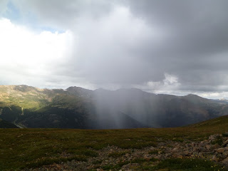
| Rain showers close in on Mt. Sniktau. |
The summit appears to be pyramid shaped. The peak is nothing more than an area of exposed rock.
Dark clouds are in the area so we choose a spot, and have a chilly lunch.
The weather forecast is for early afternoon severe storms. Rather than continue on with the possibility of being chased off the summit before lunch would not be popular.
The better decision is to leave the final summit for a better weather day. All members in the group today made it to this point.
On the return trip to the TH, we can hear thunder and see sheets of foggy rain around us. Now, it's a matter of everyone getting back to the van safe and dry.
 |
| Four HCH members, Linda and Robert Saiz, Luisa Sandoval and Nancy Bralic, do a rendition of the YMCA song. |
Total miles = 7
Total elevation gain = 1,162'


No comments:
Post a Comment