Thursday, May 31, 2012

This one...a "Keeper."

There are times when an experience turns out to be perfect in every way for all participants.  So it was this week for members of the High Country Hiker (HCH) group.
Typical CT trailhead marker

Anyone who has hiked one or more of the 28 sections of the Colorado Trail (CT), knows most of it is above 10,000' elevation.  The trail is detailed section by section in the book titled The Colorado Trail, seventh edition, revised, and published by CMC Press.

The words of CT Foundation founder, Judy Gaskill, best describe the 468-mile long trail between Denver and Durango.  It is "A Wilderness path designed to traverse some of the most scenic areas of the Rockies and the Continental Divide."  The highest point is 13,271' above sea level.

According to HCH member, Marsha McBurnett, the mild elevation gain (600' or less), the continuous canopy provided by conifer trees, a cool breeze, the length of the hike, and great camaraderie among members of this group were perfect.  Beyond that, simply being outdoors in Colorado, provides a wonderful adventure.
Sharon, Marsha, and Clietta prepare for the day, while Leaman looks on.

The trail wandered along the base of the ridge, then climbed the north face of another hill.  At the top of a rise, the view of the Little Scraggy formation opened up. 

As is customary on day hikes with HCH, the spot chosen for lunch sometimes separates those hikers who are a bit more adventurous, and have the stamina to explore, from others who are quite happy to have lunch with friends outdoors.  About half remained at the lunch area, while the rest continued on.

Sections of trail are covered with decomposed granite providing a smooth walking surface.  In some areas bikes have eroded trail into a "V" shape.

Various rock formations would highlight the day, including many small outcroppings and of course, Little Scraggy Peak.  It is actually a long ridge with several summits which stretch out along the western side of CR 126.
One of a number of rock features on trail.

Some of the more prominent flowers and trees identified were Smooth Brome grass, Rocky Mountain maple, a spent Pasque flower going to seed, Cinquefoil, Stonecrop, Clover, Wild Strawberry, Wild Rose.  There were two intriguing unidentified flowers, one purple and one white.  Hopefully, they will be seen again on a future hike.

A number of hikers today spent time determining the differences in the leaves between a Sulphur flower and Pussy Toes.
   
A few bikers and a party of three rock climbers were encountered today.

There is a climber on that rock face...see em?

This hike turned out to be a good one.  This particular piece of Colorado Rocky Mountain beauty is a "Keeper."

Tuesday, May 29, 2012

Pine Valley Ranch

 NOTE: Text for this post was provided by Mary K. Ryan, Gary #2, and Ed Blum.  Images provided by Mary K. Ryan.

Eleven High Country Hikers plus one new addition were on board for the drive to the trail head.  This hike started and ended on Pine Valley Ranch.  The majority of the day, however, was in Pike National Forest.   

There are over 800 acres in this Jefferson County Open Space property.  The southern-most Open Space park in the county is considered a “Jewel” because of the many activities it has to offer.
Structures at Pine Valley Ranch Trailhead.

The majority of this hike took us through a landscape devastated by fire fifteen years ago.  It was nice to see all of the new growth.

Background:
The Hayman Fire burned from  June 8, until July 2, 2002, nearly an entire month. Almost 138,000 acres burned, and the fire cost $1 billion to fight.  It was the largest fire in Colorado history.

In all, 133 homes were destroyed, 1 commercial building, and 466 outbuildings. In ONE day, 60,000 acres burned, and at one point burned 1/2 mile in just 4 minutes due to the "perfect" fire conditions at the time. The fire was caused by arson.

We walked among wild strawberries, pussy toes, and Indian paint brush.  We were blessed with light cloud cover, keeping us cool through the burn areas.
High Country HIkers (Front, L to R) Kathy, Penny, Ed, Marsha, Dorothy, Clietta, and Lela.
  (Back, L to R) Judy, Leaman, and Yohanna.

Distant views were beautiful including Finger Mountain, Ed's designation, observation rock, Gary #1's designation, and the refreshing Pine Lake.

Marsha and Leaman were troopers.  Leaman said, he felt better and stronger than ever since he has been riding his bike.
Along the North Fork of the South Platte River

There are a number of steady-paced hikers in the High Country Hikers group.  One of them, Marsha, hiked at the front of the group most of the day.  If you wind her up at the trailhead...like that famous bunny...she hikes all day.


At lunch, Dorothy found a little shade as the clouds began to part while Leaman discovered a carcass.  Ed thought it was once a large Coyote.

Sure looks like a Coyote.
We welcomed Yohanna, a new member to the group.  Hope to see her on trail often 

Returning back into the Pine Valley Ranch, on a loop route that took us on a few different trails, including Buck Gulch, Skipper, Strawberry Jack, and Park View.

This route looks up and away from Pine Lake, then down at the end of the lake to the van.

In order to make the steep descent down the back of Pine Valley Ranch easier, steps were installed.  A total of 281 were counted.  Everyone enjoyed ice cream in Morrison, before we headed back to ACAA.


Total Miles = 8 (Approximately)
Total elevation gain = 1.000’

Sunday, May 27, 2012

PAR Walk, June 3rd

Mark your calendar to be at Washington Park, in Denver, Sunday, June 3rd., for the 10th Annual Parkinson Association of the Rockies Vitality Walk.  This year, the theme is "Enhancing Lives With Every Step."
Start, finish line for the annual PAR walk.

Join me and members of the Fight PD...Exercise team when we take 2,000 steps in support of PAR.

The gun sounds, as walkers are on their way around Washington Park.
Team goal this year, is to have the largest number of walkers of any team.  At last count there are over 45 registered teams.  If we have the most walkers, we might raise record funds for PAR as well.  Some of the successful teams in terms of funds raised and number of walkers, have been around since the annual walk started.
Core members of Fight PD...Exercise team.  (L to R) Daughter, Kim; wife, JoAnn; the author;  Son-in-law, Darren.  Front: Grandsons Connor (12) and Dylan (10)
Join the "...Exercise" team on Sunday for the 2.5 mile jaunt around beautiful Washington Park, to support PAR.  I hope to see many of my fellow High Country Hiker friends there.   

Register today to walk on Sunday.  Go to the PAR website at:  parkinsonrockies.org  and click on Register Now.  All the details for the walk are on the web site.

See you on Sunday!

Wednesday, May 16, 2012

Family Time

It has been years since my wife and her family had a reunion.  The last time we had such a gathering was decades ago.

This year, one of the cousins took the responsibility to organize a long overdue get together.  Although most members still live in Central PA., some will come from as far away as Iowa, and Colorado.  Harrisburg International Airport may be as busy as the last time the Penn State football team returned from a bowl game.

The day will be one of telling old jokes, embellishing stories from our childhood, and catching up on the lives of other members of the family?

My wife has been looking forward to this trip for months.  Our oldest daughter and two grandsons will be with us.  The only one not going is our son-in-law, who will be broadcasting the #1 daily sports talk radio show (104.3 The Fan) in the Denver market.

We are flying into Philadelphia first for a day touring the historical district.  We also plan to relive the scene from the 1976 Oscar-winning movie Rocky.  Watch this blog for images of us running (some of us may walk) the 72 famous "Rocky Steps" to the Philadelphia Museum of Art.

We will spend time at the nationally recognized Civil War Museum in Harrisburg.  Research has confirmed my great grandfather was a member of the 76th Pennsylvania Infantry Regiment, Keystone Zouaves.  The museum has an exhibit of a Zouvave uniform worn in the war. 

We have been sharing information about their brave forefather, who at 18, volunteered for a three-year tour of duty, in the Union Army.  He survived furious fighting at Cold Harbor, helped destroy miles of Richmond and Petersburg RR track, and fought in the filthy trenches around Petersburg. 

His most harrowing exploit occurred aboard ship for the return to Philadelphia.  The vessel shipwrecked. He and many fellow soldiers jumped into the sea, losing all his clothing.  After six hours on a Moorhead City, N. C. beach, the men were rescued.  Five days later, the men returned to their families.      

The trip will culminate with the reunion before we return to Philadelphia for the flight back to Denver.  My trip report will be posted here on this blog sometime during the week of May 21st.  

Button Rock - Hall Ranch

Note:  Text and images provided by hike leader and driver, Ed Blum.

 A beautiful, spectacular Colorado day greeted 13 enthusiastic members of High Country Hikers for their trip to Button Rock. The group included previous hikers: Sharon, Jo, Rochelle, Penny, Kathy, Gary#1, Marilyn, Mary K, Judy, Dorothy, Ciletta and Ed.  Joining us for the first time was new hiker, Al.
Gotta love this group...always laughing, joking, gabbing.


We made a stop in Longmont, since it was unknown if their were "facilities" at the TH.  Photos were taken all day to try and impress our official photographer Gary#2 who was unable to be with us today.


Blog readers should not be concerned.  Photos of tempting trail food such as chips and moon pies are not necessarily the type of food one would actually eat on trail. 
Is that for lunch, Jonelle?

Route #36 took us through Lyons, and the Longmont Dam road, where a gate closed the road - ah ha the TH.  A single port-o-let was the extent of the facilities.

TH elevation was 6,500.'  Ed's figures showed a net elevation gain of 800' for the day.  Marilynn clocked all the ups and downs on her GPS and got 1,300'. Trip length was 7 mrt, for those staying at the lunch site and 8.5 for those going on to Nelson Ranch House.

The building sits in an ideal pioneer setting.  There is water, pasture and a northern ridge behind the house as a weather break.  The house is well preserved with a root cellar and silo.  A bluebird family has made a home in the attic on the east side.  There is a protective fence around the property.  A long lens would have made a fantastic shot of the bluebirds sticking their heads out of their "birdhouse."  

A short walk from the TH, along the North St. Vrain river on the Longmont Reservoir dirt access road, the Sleepy Loin trail breaks to the left.  Much of the elevation gain for the day is obtained on this trail.  We climb steadily with only one meadow as a respite.
Not sure if the shirt is proper attire for a hike leader.  The hat is rad!

The Button Rock trail turns left at an overview of the Ralph Price Reservoir.  The body of water is much larger than Longmont Reservoir.  The trail continues through beautiful pasture, skirts one of the small intersecting valleys with views of far away Button Rock - too far away to get a good photo without a long lens.
One of a number of rock formations on Hall Ranch.

The rock formation looks like a button lying on its side.  There were other rock formations that were closer to the trail that provided a better shot. Trail then gradually ascends the pasture to a saddle ridge, then drops down into the east valley toward Lyons.  

Nelson Ranch House is located a short distance below the saddle.  Climbing up to the saddle a long line of something appears in the distance close to the top.  Is it a rock wall or stacked timber?  Slowly it comes into focus as stacked timber. 

A Boulder County Open Space forestry crew is thinning out the Ponderosa Pine as a fire precaution.  The stacks will be sold as firewood. 
A truly diverse landscape.

Saws and ATV's are the type of equipment needed for the operation.  


A gorgeous Colorado blue sky was with us all day.  We made it back to Lyons for coffee and ice cream just as the store closed for the day, at 4 pm.


Tuesday, May 15, 2012

Hike the Canyon Event, 2012


Successful knee surgery, followed by a summer of hiking every week rekindled the spark for my passion, hiking.  The daily regiment of prescribed and self-imposed PT was behind me.

A daily exercise routine has extended my ability to enjoy life with family and friends.  My routine needed a boost, a recharge, maybe a challenge.   

It was July, 2011, when I decided to actually challenge myself.  It would be reasonable in terms of what I expected of my stamina and physical abilities.  I had kept a detailed log documenting hundreds of hikes and thousands of miles during my hiking career.  The only thing needed, one additional column to track hiking miles completed for the next ten months.
 
The kickoff was August 2.  Denver photographer and friend, Jason Hayes, signed on to document the day in photos.  Learn more about Jason by clicking on the "Hayes Photography" button at top right.
Jason Hayes, honing his craft.

We first did the North Rock Creek trail, in Eagles Nest Wilderness.  We returned to the TH and hiked the Gore Range Trail to Boulder Lake, logging 10.9 miles on the day.  Jason captured a number of awesome images.  One would be used on “The Hiker” blog home page above.
The author captures images of the Gore Range.

A few dates were highlighted as  milestones on the calendar to track progress.  The final date of the challenge would be May 10th.  My trail log would remain the repository for miles completed.  Plus, I wrote journal entries after each hike like always.  By September, there were 52.9 miles logged to the challenge.  Ahead of schedule, yes, but could I keep the pace?

That question was answered sooner than expected.  On October 18th, a 7.1 mile hike at Heil Ranch, broke the 100 mile challenge goal.  Had I been to naive to think I may have trouble hiking 100 miles in ten months?  It seemed like a  reasonable goal at the time.  

After some thought, I added a secondary challenge of completing 20 miles on snowshoes between November and March.
(L to R) Ed Blum, The Author, and Louisa Sandoval

November 1, the transition to snow shoes was made. The first hike was on the Sand Beach Lake Trail.  Hiking buddy, Ed Blum, plus Louisa Sandoval and Nancy Bralic, from High Country Hikers group signed on.

Image from North Ten Mile Creek Trail at Frisco.
By the second milestone in mid-January, 148.8 miles had been logged.  On January 5, the secondary challenge (20 miles on snowshoes) had been met with a 6.2 mile snow shoe hike on North Ten Mile Creek Trail, at Frisco.  It would be all downhill from here.

Mid-March was the third milestone.  Instead of having sub-par results, I was looking at a number that astounded me.  The mileage on snowshoes, had grown to 54.2 since November.  What would the final number be?

As the date of May 10th came closer and closer, emails went out explaining how the event would unfold.  Those who were interested were asked to first go to "The Hiker" blog and donate/pledge to PAR.  Next they were to contact me and register for the hike.
"Hike the Canyon participants, Jo and Jonelle on Eldorado Canyon Trail.


Promotional support was solicited from REI, Outdoor Mindset, Leave No Trace, and PAR. On May 10th, a small group of fun-loving enthusiasts met at Eldorado Canyon State Park for the finale.

Hike the Canyon  members (L to R) Outdoor Mindset staffer, Patti Abendroth; Beth Allen, The Author, Shirley Haithwaite, and Jo Murphy, and Jonelle Bidwell, members of High Country Hikers group in Aurora.


Each participant received a "Hike The Canyon" button.

It was a wonderful day both in terms of trail experience and of funds raised...almost $500.00. 

In the end it was not a matter of miles completed, rather it was about enjoying one of the most unique landscapes in the area.

It was about enjoying the journey.


Eldorado Canyon State Park, check it out.          


Monday, May 14, 2012

Event Story Coming

Watch for  a full report on the "Hike the Canyon" event with photos from the day, right here on this blog.  Posting is expected by noon on Tuesday, May 15th.

Wednesday, May 9, 2012

Hike The Canyon - Tomorrow

If you are registered to hike Eldorado Canyon tomorrow,  we meet at the Aurora Center for Active Adults, 6th Ave. and Del Mar at 8 a.m. sharp.  Otherwise, see you at the trailhead.  We will leave for the trailhead at 8:10 or before if registered hikers are there.  The plan is to be on trail from the Visitor Center by 9:30.

Great Fun in Historic Castlewood Canyon

Forecast, hi-36, partly cloudy.  That forecast might have kept fair weather hikers home.  Not the case for ten members of the High Country Hikers (HCH) group from Aurora.  This bunch of hardy, over age 50, outdoors men and women truly love being outside together.  Two first-timers joined in the fun, making it a bonus day.

The ride south on highway 83 past Parker and Franktown brought us to one gem of a State Park.  Castlewood Canyon is a medium size park, (about 2,600 acres - seven of the twenty-six state parks have more), and is part of the Black Forest region of Colorado.  Inside park boundaries a microcosm of rock formations, floral species, tree variations, can be found.  Plus it is a favorite spot for technical rock climbers.
Hike leader, Ed, describes various types of rock, lichen, and flora.


First time hiker with HCH, Lissa Ebersole is captivated by the view.


The park includes various ecological communities including tall stands of timber, verdant (green) riparian (living on the bank of a natural river) areas, and fragile prairie grasses.

We arrived at Canyon Point, cinched our packs, and were on trail a few minutes after 9.  The Lake Gulch Trail is a .8 mi. trek to the canyon floor.  On our descent, we met a small group of hikers from the Colorado Mountain Club.  After a brief exchange of hiker jargon, both groups were on about their plan to hike the canyon.
Linda Saiz, enjoys the view.  

We crossed the slow-moving water of Cherry Creek.  If  you stood motionless anywhere in the canyon, you could hear a mini water fall, or a small trough of water slicing through monstrous boulders strewn across the canyon floor.

One of many vistas


So many names of flora in the canyon to remember.  Not to worry, we have our own personal Naturalist to fill in all the blanks.  There was Larkspur, Lanceleaf Chiming Bells, Lupine, Poison Ivy, Wild Raspberry, Yucca, Snowberry, Chokecherry, Gambel's Oak, Wooly Mullein, Poison Hemlock, Sand Lily, Milkvetch, Purplevetch, Spring Beauty, Current, Common Juniper, and Rocky Mountain Juniper.  As for species of trees, there was Douglas Fir, Ponderosa Pine, Narrowleaf Cottonwood, Aspen, and Willow.  
Penny moves up trail after admiring a plant of Subalpine Larkspur  

At the next junction, we took the Inner Canyon Trail to one of the coolest historical sites in the area. If you have not seen the ruins of Castlewood Dam (circa 1890), up close, it is a must see. The dam was trouble from the start as engineers and politicians somehow got the faulty design approved. 

The structure leaked from the beginning.  On the night of August 3, 1933, the dam broke, flooding Denver, and killing a number of residents.  Get the full story at the park visitor center.
View of remains, Castlewood Dam (Circa 1890) from Creek Bottom Trail.
The rock/mortar structure ruptured, flooding Denver, 30 miles away.

Standing on trail looking up at the imposing structure that once held the water supply for Denver, was an ere feeling.  One of many questions: What kind of machinery was used to position all the rock? 

Hike Leader, Ed Blum, told the story of the night the dam became the source of terror for the residents of Denver.  Blum is a Naturalist with The Wildlife Experience, in Parker.  The group is fortunate to have this experienced man as a hike leader and driver.

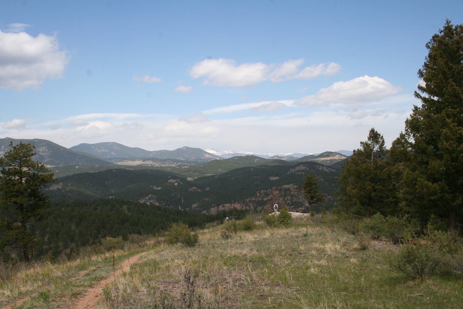
Now on the 1.7 mi. Creek Bottom Trail, our route connects with Rimrock Trail.  Views in this area are spectacular.  Standing on the edge of this canyon, looking across miles of a valley once covered with water gave one pause.  What would I be seeing from this spot millions of years ago?

Looking over the North rim.

It was late morning when some hikers began asking, when do we stop for lunch.  Between us and the rim, a stretch of natural stone and man-made steps, plus a few short switchbacks and open trail.

Ed and the Gargoyle.

The early morning chill was gone, replaced with a comfortable amount of sun.  A number of hikers shed a layer or two during the ascent.

Lunch on the Rimrock Trail is one of those experiences where if you force yourself to look closely, you find you are close to civilization.  A pair of turkey vultures gliding overhead, a solo dead tree that seems to be 'growing' out of a slab of solid rock, and a natural rock formation that looks like over sized butt-cheeks, make the list of special memories one takes from this day.  
A lone cottonwood clings to life.

A number of traditional PB&J sandwiches were consumed before Gary #2 offered a mini serving of real backcountry style dessert.  The taste of warm re-hydrated raspberries in sauce, topped with chocolate cookie crumb sprinkles, was better than some expected.    

On trail again, we approach a spot where we are directly across the canyon from the Dam ruins we walked beneath hours earlier. The structure is a bit less imposing from above compared to the view from below this morning.
Near the end of a challenging 7+ mile day, smiles still come easy.

We continue along the canyons east rim to a spot where trail turns back on itself and makes a steep descent once again to the canyon floor.  This is where the weekly group photo is taken. Everyone appears to be in great spirits, considering the size of the smiles.
One of many unique images.
    
The descent into the canyon brings us to the Inner Canyon Trail.  This 1.2 mi. path scoots among the boulders on the north side of the canyon wall.  Every short up here is rewarded with a similar size descent.

Although trail conditions overall today were good, there were brief sections of wet to muddy ground.  A few low spots had standing water, causing hikers to make quick changes in their stride.
This is why sturdy, comfortable boots are necessary.
 
As we reach the junction of Rimrock and Inner Canyon trails, we follow the latter about 1.2 mi. along the canyons north wall to a junction with Canyon View Nature Trail.  That will take us across the canyon on a wooden foot bridge.  Considering what we have seen and experienced in this small yet vibrant canyon, may place it on a short list of places to revisit with friends and family.   
One more crossing and one more up.

The final climb out of Castlewood Canyon is comforting due to the 100% canopy provided by some old Douglas Fir and Ponderosa Pine trees.  On the ascent, Ed recognizes a Ranger named Lisa.  Tasked with checking trail and backcountry conditions, Lisa told us she most enjoys meeting people and providing them information on the park.

Once again, a hike with memories to savor, and photos to rekindle those memories.  Those who hiked trails of Castlewood Canyon today, experienced what may be the most eclectic hike of the 2012 season. 
Castlewood Canyon State Park - A Gem!

A total of 198 images captured today, 149 were keepers...a good day.  If you were part of the group to hike Castlewood Canyon,  your images will be emailed to you soon.  It took more time to write and edit this piece than normal.  So be patient.


Hiking in Castlewood Canyon

The author is working on his journal entry.  A draft is finished.  Almost 200 images were taken during the hike. That requires time to review and delete those that are not acceptable.  The story will be posted later today.  

Saturday, May 5, 2012

Hike The Canyon Update

A few openings remain for this great hike in Eldorado Canyon.  If you are interested, contact "The Hiker" for details at: thecohiker2011@gmail.com 

Series: 10 Ways to Help you Live a Healthy Lifestyle

#5 Challenge Yourself:

This is the one element of living healthy that gets me fired up.   There have been occasions where a self-imposed challenge was what I needed to get past a personal set back, the loss of a loved one, or a career changing decision.

The most recent set back, had the potential to render my passion for hiking indefinitely suspended if not totally over.  The thought of not having a backpack to load, a trip plan to develop, or a trail to hike, was not one of the "Life" cards I knew I had in my hand.

I had a partial knee replacement in February, 2011.  Normal post surgery recovery is three days.  I lobbied hard to my surgeon, the nurses, the night duty shift supervisor, and anybody who came into my room.  I was home in two days.  My surgeon prescribed six weeks of PT to renew mobility and strength in my leg.  That went well.  An additional six weeks after that, I spent time in the gym five days a week, to restore muscle and tone.

Two weeks before my planned return to hiking, I tested the knee with an easy 2.5 mile hike.  The pain was gone,  The steel and titanium replacement parts were holding up well.  Two weeks later, I was back on trail with the High Country Hikers group from Aurora.  I went hiking every week over the summer. 

I was preparing for the transition to snowshoes when an idea hit me. I decided to make a self-imposed challenge, to really test my stamina, my physical and mental toughness, and those metal parts in my reconstructed knee.  The surgeon said I could expect to get ten years of normal hiking out of the new knee. .

The challenge:
  • Hike 100 miles between August 2, 2011 to May 10th. 2012.
  • Hike 20 miles on snowshoes from October, 2011 thru March 2012.
  • Raise $1,000.00 for PAR in the process.
At this writing the first two parts of the challenge have been shattered.  The 100 mile mark was achieved on October 18th.  The snowshoe mark was achieved January 24th.  Actual miles achieved will be revealed on May 10th.  The third is ongoing because the last day of the fundraising part is less than a week away.
    

Wednesday, May 2, 2012

Need to Hear From You!

OK, April was parkinson awareness month.   Over the course of those thirty days, we discussed meds. for PD, memory loss, changes in ones skin, nutrition and PD, family support, PD and children/grandchildren,  walking poles, and brain power is helped by hiking.

Now it's time for our readers to give their thoughts of what they found, what they read, and what they thought of what they read.  Send us your comments...good, bad, or ugly to: thecohiker2011@gmail.com  

We will be posting new articles and information daily.  That means what was here on page one, yesterday, is now shifted back.  You will either need to scroll back or click on the topic you want from the blog archives at the far right of the home page.

Write us today.

Tuesday, May 1, 2012

O'Fallon Park Loop

All 13 seats on the bus were filled AGAIN for a day on trails in O'Fallon Park.  The park is one of many such gems for physical exercise in the Jefferson County Open Space system.   Hikers arrived at the park on Bear Creek, at 9:30.  With only a few steps to the TH, hikers were cinched in their packs and on trail by 9:40.
Members of 'High Country Hikers' on their way to Vista Point.

Beginning with the Picnic Loop Trail, we started almost immediately to gain elevation.  In fact, most of the 800+' gain on the day was realized in the first hour on trail.  Conditions were dry grass and dusty trails.  So dry, even the passing of two cyclists caused a small cloud of dust.  As we approach the junction with West Ridge Loop Trail we soon reach the top of the ridge.  Hearts are pounding in chests, lungs are taking in huge amounts of extra air.
Betty has  shed a layer of clothes while Dorothy maintains a steady pace.

Can't get enough of those snow-capped mountains.
Then the payoff, looking west, the snow-covered face of Mt. Evans (14,254'). A magazine cover type beautiful monster mountain.  Cameras are out, shutters clicking again and again.  Due to an electronic malfunction in my large zoom lense, I am reduced to making class b shots.

Kathy reluctantly leaves her spot, after enjoying the best view during lunch in recent memory.  Hey Penny, you gonna sit there all day?
From here, trail snakes its way through a number of stands of Ponderosa Pine and Douglas Fir, then slices across small meadows.  Canopy today is varied from zero to maybe 60%.  Cloud cover and a mild breeze kept surface temperatures moderate.
A Pasque flower, one of the first to bloom in spring.

Since leaving the TH, we have been on trail less than two hours.  Just ahead is Vista Point, a 270+ degree view of the mountains to the west and northwest.  Mt Evans, has a series of cirques around it.  They are the deepest cirques in the Rockies.
View of Vista Point from Meadow View Loop Trail.

A great spot to rest, have lunch, enjoy the mid-day breeze and a brisk conversation with fellow-hikers.  Based on the fact they hike the majority of all scheduled hikes in a season, every person today is considered a core member of High Country Hikers.  How do we know that?  We had a relaxing lunch and were repacked, ready to return to trail in thirty minutes.
Judy, Ed, and Marilynn steppin out at a good pace.

With everyone in a relaxed mode, Gary2 took the group photo.  A few members didn't make the shot.  They were still soaking in the scenery at Vista Point.
High Country Hiker members: Front (L - R) Betty, Marsha, and Clietta; Standing (L - R) Marilynn, Dorothy, and Jonelle; Sitting Back Row (L - R) Judy, and Rochelle

On trail for the gradual descent back to Meadow View Loop Trail.  It's now after lunch, so it's no surprise that conversation turned to the question...Where is the best place to stop for Ice Cream?  The consensus, the place on main street in Morrison.
Ever see a bronze colored ball growing on a pine tree?  Marilynn checked it out up close.

Our final descent to the van is a gradual one, with some degree of concern for unexpected slippage on loose gravel or someone making a misstep on a rock.  The route today seemed short to some compared to many ACAA scheduled hikes.  In fact, the group hiked a total of 4.1 miles and accomplished total elevation gain of 837' on the day.
A parting image from the bridge over Bear Creek.  Hope the lone fisherman has luck today.


10 Ways to Improve Ones Quality of Life

Last August 14th, the first of ten elements was posted on this blog.  To date we have covered nine, including this one.  It is no less important than the rest.  What is it?

Simplify your life...Don't Stress Out:

That statement is easy to say.  It can be quite difficult to put into practice.  I tell my wife all the time, don't get upset when the pork roast in the crock pot didn't turn out exactly how she planned.  It tasted great.  If she had not told me she missed adding an ingredient before turning the unit on, I would not have known it.

I understand it is all about a persons expectations.  My wife knew exactly what to add to the roast and exactly how much of the ingredient to add. but she forgot.  It was a big deal to her because she sets high standards for herself, with everything she does.

One thing we both have learned is to keep clutter to a minimum in the house, in the garage, and in the trunk of the car.  Today was spring turnover day.  That means, we both gathered our winter clothing, long sleeved shirts, sweaters, and flannel PJ's.  They were either placed in large containers and stored, or hung in the back of a closet and covered with a clothing bag to protect them.

Next, we went through all the summer clothes and made a decision on each one.  Keep it or bag it for charity?

We have always lived within our means.  That is difficult for many to do.  A plastic card makes it too easy to purchase an item, without thinking if you really need it.  We have never missed a mortgage payment, or a car payment.  I say that with a certain degree of pride.  To many with a large debt, it must be realized that with debt goes stress.

People must prioritize things in life.  We don't often hear about people who cut things out of their schedule that were not a priority.  We have all said "Yes" to things that we knew at the time, we should have said "No."  Like anything, there is discipline involved.  Like allowing family debt to soar out of control, we need to stick with the top priority items in life to be happy.

It's all part of that "Journey" I talk about often.  The journey of life, that is.