Thursday, July 26, 2012

MIlls Lake - A Quintessential Place

When the destination is RMNP, adrenaline starts pumping the instant my feet touch the floor in the morning. 

There was no time to properly load my pack.  Items were grabbed from storage shelves and tossed into the empty cavity.  More time was taken to fill the 100 oz. bladder than the entire pack. Est. weight, about 36# 8.0 oz.
RTD would love this  level of dedication to public transportation.

Arriving at ACAA with minutes to spare, put me last to board the van.  Early morning traffic on I 70 and gawkers on our approach to Estes Park left some on the van to question if we would make the park checkpoint by 9 a.m. 

We must have the worlds best and luckiest van driver in Ed Blum.  We arrive at the checkpoint at 9:03.  There are three vehicles in line.  Will they be asked to turn around or allowed to continue to the shuttle bus site.

At 9:05 we reach the checkpoint with two park rangers standing in the middle of a dusty construction site.  One told Ed, "I was thinking about when I should start turning vehicles around."  With that, Blum stepped on the throttle propelling us down Bear Lake Road.

Authors Note:  Over the next two years, park visitors can expect major construction on the lower 5.1 mile Bear Lake Road.  Crews have already stripped the old road surface leaving a mini dust bowl for park visitors.   Road work begins at Trail Ridge Road/Highway 36 and continues to the Bear Lake/Glacier Basin Campground intersection.  The span is being upgraded with retaining walls, and proper drainage before a new surface is installed.  The two-year project will include a reroute of about a mile of road away from wetlands, plus fix a number of old problems.  
Two guys enjoy a moment of solitude and natural beauty.

Last year, 440,000 visitors rode a shuttle bus to one of the TH's in this part of the park.  As we turn the corner into the shuttle lot,  the line of visitors already waiting for a shuttle bus is quite long.
HCH members approach the talus field. 

The ride to Glacier Gorge TH is short.  After cinching our packs, I noticed a group of eight fishermen talking about what they would be doing today.  "You guys in a fishing club," I asked.  "No, we just decided to get together and go fishing today," one said.  Another added, "We are all from Longmont, except one (pointing to what appeared to be the senior member of the group), he is from Oklahoma."
Sections of trail offer hikers man-made steps to get to the top.

The TH at 9,240' elevation, leads to a solid and wide section.  Later trail becomes narrow for the .6 mi. to Alberta Falls.  Another .7 mi., to the junction with North Longs Peak Trail.  And another .6 mi. to the junction with Lock Vale (Valley) and Black Lake Trails.
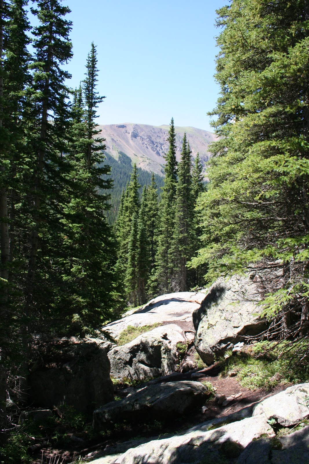
On approach to the lake,  trail becomes solid rock

Alberta Falls is running fast and furious this time of year.  A wonderful place to rest, take photos, or just soak up the soothing sounds of the falls.  As we make our way up Glacier Gorge Trail, we are faced with a section of rock debris called talus.  After that, hikers are moderately challenged by rock steps, a few muddy spots, and some lazy switchbacks before reaching a section of solid rock just before the lake appears thru the trees.
It keeps getting better and better.

As is the case with most lakes in the park, views from virtually any spot is one of unique beauty.  Longs Peak, with it's majestic 14,255' summit, peaks out between Mt. Lady Washington (6,328) and Pagoda Mtn. (132,497).  Pagoda is next to Chiefs Head Mtn. (132,579).  Dove Glacier clings to the west face of Longs Peak.  Mills Glacier is nestled between Chiefs Head and Pagoda Mtn.
Incredible!

No spot...a rock, a clump of grass, a log, or at waters edge...is a bad spot to have lunch at Mills Lake.

I learn I am not the only one who made a hasty exit from the house this morning.  It seems Ed forgot his lunch in the frig.  Not to worry...included in the items Gary2 tossed in his pack was a backpacking stove, some freeze-dried meals, a bowl and utensils.  Other members of the group offered Ed fresh fruits.  Nobody would go hungry today.  In minutes, Gary2 had a pot of Lasagna with meat sauce to share.
A friendly Hoary Comma displays its best pose.
It likes to rest on soft meaty surfaces.

There are times when nature provides an unexpected surprise.  My eye caught movement beside me.  On an exposed tree root, flexing its wings in the bright sunlight was a beautiful Hoary Comma butterfly.  Commonly seen in the rocky mountains, this guy seemed to have no problem hanging out with us.  A moment later John said, "Hey, he's on my sock."  
I do not want to leave.

While repacking the kitchen, a knife I was holding slipped out of my hand and into the lake.  "I'll grab your belt if you can reach down and get it," Ed said.  John made sure neither of us would go head first into the water by holding Ed's arm.  The knife was retrieved on the first try.  The only problem was the full weggie Ed left me with was extended as he gave an extra tug on my belt before letting go.  Thanks buddy!
Trust me, the water is NOT as cold as it is clear.

The thought of leaving a scene like this was a bit sad.  Certainly many visitors we passed on trail today felt the same.  I regularly take the sweep position on trail.  It provides me the opportunity to stop, turn and take one more look at the unique landscapes we have enjoyed.
The lucky ones plus two new High Country Hiker members from Indiana. (Kate Hiser-pink hat-and husband Mike behind her) 

A group photo was a must this trip.  As Gary2 was setting up the camera, somebody became engaged in conversation with a couple.  The two were invited to be instant members of High Country Hikers.  After the shot, Gary2 learned the couple from Carmel, Indiana were Kate and Mike Hiser.  Carmel is located just north of Indianapolis, the former home of Peyton Manning, now a Denver Bronco.  Our request for information on their trip to RMNP has gone unanswered.  The reply to our email indicated they would return home next week.  Check back for an update to this posting.
It's all about the journey...enjoy it.
 
Our shuttle bus connection at the TH went well.  We were back at the pick-up lot and on or way out of the park by 3:15.  A stop at the Colorado Cherry Company, midway between Estes Park and Lyons, proved good for everyone.  Their specialty, home made cherry pie.  Just like grandma used to make...ALMOST!

Total miles = 5.0

Total elevation gain = 700'


Wednesday, July 18, 2012

Vistas, Wildflowers, and Waterfalls, OH MY!

The imposing East Portal TH (8,950') leaves hikers with uncharacteristic sounds and images of traditional trailheads.  If you remove the lush mountains of James Peak Wilderness, the site is nothing more than a remote railroad siding.  On our approach to the TH, we crossed the tracks seconds after a train of coal cars had passed.  The TH doubles as a layover point for coal mined in Wyoming.


The first mile plus takes hikers through a number of open meadows surrounded by tall stands of aspen and conifers.  At the 1.8 mile point, trail becomes more challenging as it continues over house-size bolders, up stone stairs, across a number of streams before switchbacks take us up, up and away.
Grassy meadows filled with wildflowers set the stage for a colorful hike.

Elevation gain of 1,400' or more is not a problem for most HCH members.  Most of the group of 14 were up to the challenges of the day.  A few settled for a slower pace.
Hikers take a break on trail.

First glimpse of Crater Lake caused more than one to exclaim "Wow, look at that," referring to the beautiful setting.  Wildflowers can make a wonderful hike into an awesome hike.  Today was an awesome hike.
First glimpse of Crater Lake.

Although the author missed a number of hikes this season, the setting we found ourselves in for Lunch may have been the most scenic, the most remote, with unequaled solitude.
PB&J, tuna salad, nuts, and fresh fruit never tasted this good. 

Someone threw out an added challenge to climb another 500' above the lake to get the best view.  Five, including the author, said yes.  As the group made their way beyond the lake, they were  looking for a trail that would take them to the base of a roaring water fall that feeds Crater Lake.
Challenged by yet another up, Al surges ahead. 

The sound of thrashing water over solid rock, not a trail, led these adventurous soles to the final climb of the day and one of the most beautiful spots this sole has been to.  Nope, not even some hand over foot alpine scrambling would intimidate these adventurous soles.
Look closely, Judy (left) and Ed (behind falls) have the best view of Lone Eagle Peak and the surrounding wilderness.

A new member of the group this season, Al Akell said, "The lower lakes were a great end to the hike.  I especially liked the path between the two boulders which reminded me of a taco shell.  I only wish we could have found the trail to the upper lakes on the way up...not on the way down."
This is about as good as it gets!

Perched high above the lake, surrounded by a host of colorful friends including Violet Aster, Red Clover, Elephantella, Paint Brush, Biswort, Parry's Bellflower, Black-eyed Susan and Rocky Mountain Daisies, one might think one was in another world.
A most colorful meadow.

By 1:30, the five mountain goats were lakeside again, cinching down their packs for the return trek.  Soonafter leaving the lake, a gear malfunction of sorts.  During our descent, Dorothy Stromberg 'blew a tire.'  That is to say, the entire tread (toe to heel) peeled off her boot in one piece.  Minutes later, Gary 2 had secured the tread in place using...yes that old faithful...duct tape.  The four to five-foot-long piece of tape had been wrapped around one of his hiking poles since the start of the hiking season.  As for Dorothy, she was able to walk normally the remaining 2+ miles to the TH.
Experienced hikers are prepared. Gary 1gives Dorothy a temporary retread after she 'blew a shoe.' 
STOP! Enjoy the view.

A number of HCH members took time to express their thoughts about the outing.  "This has to be my favorite hike," Mary K. Ryan said.  "It was quite an adventure, mixed with beauty, and great exercise.  The lake view was awesome! Could not have picked a better spot for lunch," she added.
What's not to like.

One way the author can gauge how good a hike it was is by simply checking the cameras image counter.  The number today was a healthy 223 images.  For this life-long hiker, the excitement of a hike will continue well into the night.  A quick review of all images captured from the day is followed by a more critical eye that looks for the best of the best images.
Solitude, sweet solitude.

This was a banner day in terms of good to very good and a few exceptional images.  Final number of keepers...196.     

Total miles = 6.6 (+ 2 additional for the five who were not satisfied)

Total elevation gain = 1,400' (+ 400 for the five mountain goats)


Friday, July 13, 2012

Colorado Trail to Guller Creek

This hike began on the ski slopes of Copper Mountain Resort.  "We hiked across a few ski slopes before ascending to the Colorado Trail (CT)," according to Mary Kay Ryan, a High Country Hiker core member.
View from trail of Copper Mountain Resort as the hiking day begins.
The gradual increase in elevation keeps everybody happy.

"The trail was busy," Ryan added.  The group of 13 soon would meet a thru-hiker named Blake, who was hiking the entire 500 mi. CT from Denver to Durango.  "Later we met a couple also headed for Durango, plus two young women who started in Mexico.  Their goal was to reach Canada by mid-September," Mary Kay told us.
Hike leader, Ed Blum talks with a trail crew member.

"Later in the day, there was a unique opportunity to meet members of two volunteer trail crews.  They were loading rocks into buckets, clearing debris and building a trail bridge," Ryan explained.

We wanted to get an update on the progress this crew made since Tuesday.  So about 11:00 a,m, on Friday, three days after the HCH last talked to the crew, we called Steve Stadler, one of two Crew Leaders assigned to the Guller Creek Project.  Stadler answered our call from the Guller Creek work site.  When asked to describe the current status of the project, Stadler said, "We finished the bridge twenty minutes ago.  We are now working on access ramps on the east and west side of the bridge.  Next, we will be tearing out the pedestrian crossing and rebuilding it into an equestrian crossing.

After explaining the reason for our call...his comments would appear in "The Hiker" blog...Stadler asked for contact information about the blog.  "I will pass the blog address on to the Colorado Trail staff," he added.  
A long and relaxing lunch in a meadow.
A well-built beaver pond.
According to the CT web site, this crew is working together for one full week.  Crew members camp at Copper Mountain Ski Area, then walk a mile each morning to the work site at Guller Creek.

A section of the CT was rerouted above the resort in 2002.  It crosses several ski runs, travels under chairlifts, drops near the village then winds down to meet the older part of the CT near the confluence of Jacque Creek and Guller Creek.  Ryan noted, "We expressed our appreciation for their hard work," referring to crew members.
Can that downed tree be trusted to hold everybody?

Canopy provided intermittent shade throughout the 6.6-mile trek.  On the day, there was approximately 900' of elevation gain.  Ryan said, "The views were gorgeous."  John Tedrick agreed, saying, "The views were phenomenal."

Lunch break was nice and relaxing by several beaver ponds.  Tedrick added, "The beaver ponds held small brook trout.  They appeared to be holding in riffles waiting for a snack to come floating by."
HCH members pose for the camera.

An experienced hiker and backpacker, Tedrick noted "The hiking was very good.  The trail was in good shape." John also observed, "When crossing the ski runs, small bits of trash (bits of velcro, water bottle tops, broken pieces of bindings, bottle caps) dropped by skiers and boarders during the ski season.

Referring to the overall experience, Mary Kay told us "A stop for ice cream at Annie's in Frisco, brought another beautiful day in good company," to an end.  

Authors Note:  Thanks to Mary Kay Ryan and John Tedrick for providing both general information and personal observations from the day.  Kudos to John and Mary Kay as well for capturing many of the extraordinary landscapes and the people who make every hike with the High Country Hikers a joy.

Our thanks as well to Colorado Trail Volunteer Crew Leader John Stadler for giving us an on the spot update of the Guller Creek Project.


Monday, July 9, 2012

Early Start to Lake Bierstadt Pays Off

You may have read about the increase in the number of people visiting our national parks.  More people means more wear and tear on trails, more use of roads, more stress on the entire landscape.  Federal funds have now been allocated to make repairs and upgrades to a number of issues.  Our own RMNP has a major project under way.

Work crews are in the early stages of a two-year plan to upgrade over 5 miles of Bear Lake Road in the park.  The work will include adding significant retaining walls to improve safety.  Repairs will be made on the Big Thompson Bridge. Structural deficiencies will be corrected on the roadway and parking and pullouts will be improved. 

The group of ten intrepid hikers left ACAA at 7:00 a.m., to hopefully arrive at RMNP before 9:00.  Park rangers we talked with agreed that arriving early is smart.  In fact the park web site recomends the "Best options - hike early or late - prior to 9 a.m. or after 4 p.m. or explore other areas of the park.  It all stems from the ongoing construction.
View of Lake Bierstadt from the beach.

Hike leader and driver, Ed Blum said "Taffic moved well and we reached the Beaver Meadows Entrance Station around 8:45.  The dirt road began as soon as we turned off Trail Ridge road onto Bear Lake Road.  We made it past the closure point and traveled through a portion of one way traffic with a flagmen to the Park N Ride.

Even on a Tuesday, the Bear Lake and Glacier Gorge parking areas were already full.  We took the shuttle to the Bear Lake TH, and began the only one-way through hike I can remember in three years with this group.

This was an easy hike.  Everyone enjoyed the respite from last week and the harder hikes yet to come in the snow-melted high country.  Bierstadt Lake TH is located at 8,860' elevation  We gained a mere 400' el. over the 4.5 mile trek  The trail runs parallel with the Bierstadt Moraine.
What is not to like about this image.

We gained  a ridge on the northwest side of Bear Lake, and descended to Bierstadt Lake.   We took an extended lunch break on the north shore.  Although the lake is surrounded by dense pines, we did have views of Long's Peak to the South and Hallet's Peak to the West.
Johanna has a leisure lunch while enjoying the solitude around Lake Bierstadt.

The sun was warm, the water cool, the breeze perfect.  Large varieties of dragon flies and two ducks joined us.  As we continued our descent the trail had areas of loose rock.  That soon turned to sand as if we were walking on a beach.
Dorothy (Center) enjoys the sun while Elizabeth (bottom right) takes in the view.

While leaving Estes Park, someone noticed a "Senior Museum."  Nobody wanted to stop for fear it was full of people who looked like us.  Who would want that?
One of our winged friends flew in for a visit.

On this day before the nation celebrates its independence birthday, we saw and enjoyed a wonderfully well preserved and maintained piece of natural Rocky Mountain beauty. 
This is why we hike.


Author's Note:  A special thanks to Nancy Bralic and Ed Blum for providing both text and images from this hike.   We encourage all members of the High Country Hiker group to email your comments to this blog.  We want to hear from you.  Send comments to: thecohiker2011@gmail.com